Tel Azekah
Azekah was an ancient town in the Shfela guarding the upper reaches of the Valley of Elah, about 26 km northwest of Hebron. The current tell by that name, also known as Tel Azeka or Tell Zakariya, has been identified with the biblical Azekah, dating back to the Canaanite period.Photo: היידן, CC BY-SA 4.0.
Notable Places in the Area
Khirbet Qeiyafa
Archaeological site
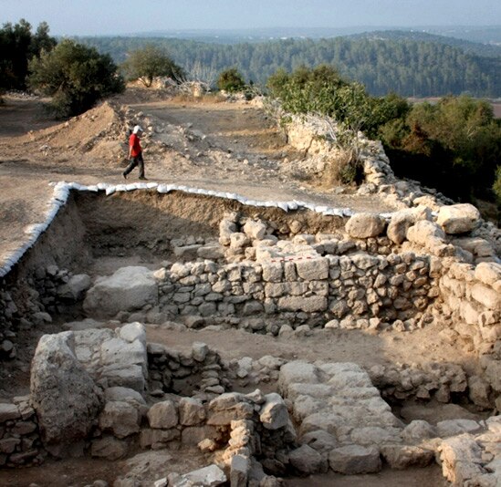
Photo: Wikimedia, CC BY-SA 3.0.
31°41′47″N 34°57′26″E / 31.69639°N 34.95722°E Khirbet Qeiyafa, also known as Elah Fortress and… Khirbet Qeiyafa is situated 2 km east of Tel Azekah.
Tel Yarmut National Park
Protected area

Photo: Shelly Eshkoli, CC BY-SA 4.0.
Tel Yarmuth or Khirbet Yarmuk is an ancient Near East archaeological site in Israel located 25 kilometers southwest of Jerusalem and near modern Beit Shemesh. Tel Yarmut National Park is situated 3½ km east of Tel Azekah.
Masua lookout
Scenic viewpoint
Photo: Wikimedia, CC BY-SA 4.0.
Masua lookout is a scenic viewpoint situated 4 km south of Tel Azekah.
Localities in the Area
Zekharia
Village

Photo: אסף.צ, CC BY-SA 3.0.
Zekharia is a moshav in central Israel. Located near Beit Shemesh, it falls under the jurisdiction of Mateh Yehuda Regional Council.
Agur
Village

Photo: Wikimedia, CC BY-SA 3.0.
Agur is a moshav in central Israel. Located near Beit Shemesh, it falls under the jurisdiction of Mateh Yehuda Regional Council.
Srigim
Village

Photo: אסף.צ, CC BY-SA 3.0.
Srigim, also known as Li On, is a community settlement in central Israel. Srigim is situated 2½ km south of Tel Azekah.
Tel Azekah
- Type: Ruins
- Description: An archaeological site in Israel
- Categories: tell, archaeological site and historic site
- Location: Jerusalem District, Israel, Middle East, Asia
- View on OpenStreetMap
Latitude
31.69917° or 31° 41' 57" northLongitude
34.93592° or 34° 56' 9" eastOpen Location Code
8G3PMWXP+M9OpenStreetMap ID
node 278478411OpenStreetMap Feature
historic=ruinsWikidata ID
Q723564Tel Azekah Satellite Map
© OpenStreetMap, Mapbox and Maxar
Also Known As
- Arabic: عزيقه
- Cebuano: Tel ‘Azeqa
- Egyptian Arabic: عزيقه
- English: Azekah
- English: Tel Azeqa
- English: Tel `Azeqa
- English: Tell Azeqa
- French: Azekah
- French: Azeqa
- French: Azeqah
- French: Azéka
- French: Azéqa
- German: Aseka
- Hebrew: עזקה
- Hebrew: תל עזקה
- Indonesian: Azeka
- Japanese: アゼカ
- Polish: Azeka
- Portuguese: Azeca
- Russian: Азек
- Russian: Азека
Landmarks in the Area
- David & Goliath LookoutScenic viewpoint
- Britain ParkPark, 1¼ km southwest
- תל שקלוןScenic viewpoint, 1½ km south
- חורבת שקלוןRuins, 1½ km south
- GatRuins, 2 km south
Places in the Area
- חניון עזקהPicnic site, 180 metres southwest
- Azeka JunctionBus stop, 720 metres east
- חניון בור המיםPicnic site, 1 km southwest
Popular Destinations in Israel
Discover Tel Aviv, Carmel Range, Haifa and Nazareth.
Escape to a Random Place
Discover other ruins in the world.
About Mapcarta. Thanks to Mapbox for providing amazing maps. Data © OpenStreetMap contributors and available under the Open Database License. Text is available under the CC BY-SA 4.0 license, excluding photos, directions and the map. Description text is based on the Wikipdia page Tel Azekah. Photo: היידן, CC BY-SA 4.0.