Gulf oil spill: the devil's cocktail
Add hurricane winds to the oil-and-water mix, and Southern coasts could face a surge of slime
On June 1, the Atlantic hurricane season kicked in, the red snapper season opened, and more than a half-million gallons of oil a day continued to spew from the Deepwater Horizon well into the Gulf of Mexico.

Charter Capt. Mike Eller followed daily reports of the massive spill and the no-fishing zone edging closer to his dock in Destin, Fla. "We're kind of on the edge of it right now," said Eller, speaking on a cell phone from his 65-foot G&S charter fishing boat Lady Em. Lady Em was 18 miles off Destin in the Gulf of Mexico on a charter fishing trip for snapper, grouper and amberjack. "We're still fishing, but I tell people we could be closed down in two days or in two to three weeks, or we might not be shut down at all. We don't know. But I feel more and more that it's inevitable we will have to shut down."
By early June, tar balls were washing up on the beaches in Pensacola, and steady winds out of the southwest were driving the oil east along the Panhandle toward Fort Walton Beach, Destin and Panama City - Florida's "Redneck Riviera," where the white sand beaches, the phalanx of oceanfront condominiums and the Gulf fishing draw crowds of beach-goers and anglers all summer long.
Charter fleets in Venice, La., Biloxi, Miss., and Orange Beach, Ala., already were boxed in by oil. Eller, who also fishes a 40-foot Infinity, Fish-N-Fool, wonders when and if the Destin fleet will find itself in the same boat. "This is high season," says the co-president of the Destin Charter Boat Association. "This is when we make our year's money - the next two-and-a-half months."
Anticipating that oil would be at Destin's doorstep long before summer's end, many of the town's 100 or so charter captains cancelled their summer bookings and signed up to work for BP's "vessel of opportunity" program to help in the cleanup, Eller says. He plans to fish as long as possible, hoping to make it through the summer, but if oil shuts him down, he, too, might apply to BP, if it's still hiring, he says.
"It's going to be a long, drawn-out, painful ordeal," says Eller, who has worked 35 of his 49 years on charter boats. "We've got some very, very life-changing ramifications ahead of us. Worst case, I won't be able to make the boat payments and will have to tie the boat up and take the keys to the bank."
On the 56th day after the Deepwater rig exploded, killing 11 workers, BP had fitted a cap on the blown well head and was pumping an estimated 630,000 gallons of oil to the surface. The latest estimate of the spill's size was 1.47 million to 2.52 million gallons a day spewing into the Gulf. Conservatively, an estimated 82 million gallons already had escaped, threatening coastline from Louisiana to Mississippi, Alabama and Florida - even the Keys. At 82 millions gallons, the spill already was more than seven times the size of the 1989 Exxon Valdez tanker spill in Alaska.
BP was deploying a second containment device in mid-June that it hoped would capture another 840,000 to 1.176 million gallons a day once fully operational. It expected to be capturing a total of 1.68 million to 2.226 million gallons per day by the end of June and 2.52 million to 3.36 million gallons daily by mid-July.
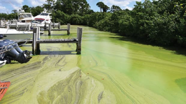
As of June 2, the National Oceanic and Atmospheric Administration had closed fishing in 37 percent of Gulf of Mexico federal waters - 88,522 square miles - an area that stretches from Morgan City, La., to Pensacola, Fla., and southeast off the Dry Tortugas. In the north, surface oil, from a light sheen to a rusty brown sludge, had washed onto beaches and into marshes and estuaries along 120 miles of northern Gulf coast. Heart-wrenching photos of seabirds - dead and alive, coated and mired in the sludge - on the region's barrier islands drove home the true scale and cost of the calamity. It is being called the worst man-made environmental disaster in the nation's history.

A busy storm season
Compounding the uncertainty, NOAA has predicted an "active to extremely active" hurricane season, with a 70 percent probability of 14 to 23 named storms (top winds of 39 mph or higher); eight to 14 hurricanes (74 mph or greater); and three to seven major hurricanes (at least 111 mph). The other principal source of hurricane forecasts, the team at Colorado State University, also was predicting a "very active" season, with a 51 percent chance a major hurricane will hit the U.S. East Coast, including the Florida Peninsula, and a 51 percent chance of one socking the Gulf Coast between the Florida Panhandle and Brownsville, Texas.
NOAA, in a fact sheet about the interaction of hurricanes and oil spills, says the surface oil is likely to have little effect on the storms' strength or the severity of their surges, but - on the plus side - a hurricane could disperse and weather the oil, and speed up the work of bacteria feeding on it and degrading it.
On the negative side, NOAA says storm surge could be expected to wash oil as far inland as the surge reaches, contaminating the mountains of storm debris. This is what worries Nan Walker, an oceanographer with Louisiana State University's Coastal Studies Institute. Walker says a 10-foot surge would inundate the Mississippi Delta, which extends about 25 miles into the Gulf. "Our whole coastal area is marsh," she says. "The marshes are very flat. It wouldn't take more than a 10-foot surge to submerge that whole area."
At Waveland, Miss., where Hurricane Katrina delivered its hardest punch, a 30-foot surge pushed a mile inland, leaving many homes far from the beachfronts with eight feet of water in them. "A lot of our coastal area would be affected," says Walker. "How much of a concentration of oil would there be in the water, we don't know."
After Katrina, Louisiana lost about 30 percent of its land mass, she says, much of that marshlands. Those marshes are now under water. With an oil-tainted surge, she says, "The potential is there that more marshes will die. What we don't know is how long it will take for them to grow back."
Many scientists, including Walker, fear the surface oil is just the tip of the iceberg. At least two research vessels have detected vast underwater plumes of oil droplets suspended like toxic vinaigrettes in water at depths of 1,000 feet or more. Created by chemical dispersants and the mixing and dispersing action of waves, these plumes are invisible to the satellites that track the surface oil and remain a real threat to undersea life, as they ride currents across the Gulf.
Carried over Keys reefs on the Gulf Stream, this submerged oil could coat and kill the reefs, which harbor a vast array of marine life and draw anglers and divers from around the world, says Richard Dodge, an oceanographer and dean of the Nova Southeastern Oceanographic Center in Dania Beach, Fla. "The real toxic effects will come from that dispersed oil," he predicts.
If a hurricane does hit the Gulf, BP will have to cease its oil pumping operations at the wellhead, as well as its work on drilling a relief well and cleaning up the Gulf - all of which could extend the timeline for diminishing the threat, authorities say.

So many unknowns
Up and down the Gulf Coast, charter captains, pleasure boaters, marina and boatyard operators - anyone who lives or works on or loves the water - were looking ahead to a summer of uncertainty and dread. Scientists were deploying every trick in their bag - satellite imagery, research vessels, aircraft overflights, computer modeling, even a remote-controlled torpedo with sensors - to track the oil on the water and beneath it. Their intent is to project where it might be headed, in what form and with what consequences.
Roffs (www.roffs.com), a fisheries, oceanography and environmental sciences firm that was tracking the spill by satellite, projects that some of the oil will ride a Gulf highway known as the Loop Current south to the Gulf Stream. There it would be swept east through the Straits of Florida, maybe 15 to 20 miles off the Keys and as little as two to three miles off the Palm Beaches, and carried on the stream up the Eastern Seaboard to the Outer Banks of North Carolina and east into the Atlantic.
Roffs also was concerned that oil invading the Panhandle might hitch a ride with currents running southeast along the Florida shelf off Tampa-St.
Petersburg, Sarasota, Fort Myers and Naples, though that was not imminent in early June.
The oil almost certainly will ride the Loop Current into the Straits of Florida, says oceanographer Dodge. "How much, when and in what form we just don't know," he says. And therein lies the dilemma for emergency managers and others trying to anticipate developments. Dodge attended a meeting in South Florida where Capt. James Fitton, commander of Coast Guard Sector Miami, was asked if he was ready for oil. "He said, ‘I'm ready,' " Dodge reports. " ‘I'm just not sure what I'm going to do. I don't have a defined threat yet.' "
That is the problem for communities up and down the Gulf Coast. They don't know what to expect, when to expect it or whether it would come at all. That uncertainty - and the misperception that oil already is washing ashore all along the Gulf - has disrupted many tourism-based economies.
"We've taken a significant hit," says Andy Newman, media relations director for the Florida Keys Tourism Council. "We've had [hotel and charter boat] cancellations. It's a real big concern."
Traveling hundreds of miles south on Gulf currents, the surface oil was expected to evaporate and turn from a sheen to a thick pudding and then, as the pudding breaks up and weathers, into tar balls. The best-case scenario is that as the oil travels the Loop Current most of it will be in the form of tar balls when it reaches the Keys, says oceanographer Dodge. Tar balls float in the water column, so they are not likely to damage the reefs.
Depending on winds and currents, the tar balls could be deposited on Keys beaches - a nuisance but not a catastrophe - but Newman says there's a 50-50 chance "they'll go right by us." Caught up in the Gulf Stream, those very same tar balls could wind up on the Outer Banks.
Computer simulations at the National Center for Atmospheric Research in Boulder, Colo., suggest the spill's impact will not be limited to the Gulf but will have wide-ranging implications. Scientists at the center say that once surface oil - oil suspended in the top 65 feet of the water column - is entrained in the Loop Current, its southerly movement will rev up to 40 miles a day, and when it gets into the Gulf Stream it will speed up to 100 miles a day. A map of what scientists expect shows oil in the Gulf Stream slipping through the Straits of Florida, then hugging the coasts of Florida, Georgia and the Carolinas to Cape Hatteras, where it turns east and disperses in the Atlantic.
"Whether the oil will be a thin film on the surface or mostly subsurface due to mixing in the uppermost region of the ocean is not known," their analysis says.
Taking a big hit
In Florida, tourism officials and tourist-dependent marine business owners expressed frustration over visitor cancellations while the spill's behavior still was very much in doubt. "There has just been a heavy, heavy, heavy focus [on the oil threat to the Keys] when in fact we haven't seen the first tar ball from the spill," the tourism council's Newman said at the end of May. When tar balls turned up on the beach at Key West's Fort Zachary Taylor State Park earlier in the month, news stories trumpeted that the spill had reached the Keys - an assumption proven false 36 hours later when a lab analysis showed the tar wasn't from Deepwater.
The Keys weren't the only destinations affected. Pre-Memorial Day surveys of Fort Lauderdale-area businesses revealed few hotel-room cancellations but lots of changes in plans to go out on the water, according to Francine Mason, vice president of communications for the Greater Fort Lauderdale Convention and Visitors Bureau. "Fishing, boating, diving," she says, "they were the only ones getting cancellations. It was because of the uncertainty - the lack of clarity - about the status of the water. Right now the water is fine."
The state of Florida and local tourism boards mounted aggressive campaigns to make precisely that point. Oil company BP, which the federal government is holding responsible for the spill, gave Florida $25 million for tourism advertising. Some of that went to beefing up the VisitFlorida.com Web site, with 32 live webcams of beaches and waterfront - oil-free and inviting. Other money went to a national print and radio advertising campaign, generating "tweets" to give visitors a heads-up on where to go and what to see at different destinations, and inviting Sunshine State visitors to post their vacation photos on Florida's Facebook page, which transfers them - more than 90 at last count - to VisitFloridaLive.com.
The social media have played a big role in turning the tide of "misinformation" about oil on Florida's beaches, says Newman. The oil spill page on the Keys' official Web site(www.fla-keys.com), which shows NOAA spill maps and analyses updated daily, registered 105,000 page views between May 3 and the end of the month. "People are hungry for information," Newman says.
The Keys scored a PR coup on Memorial Day with a live "Good Morning America" broadcast from the beach at Key West's Waldorf Astoria Casa Marina Resort. The report featured weather anchor Sam Champion stretched out on a floating lounge chair with blue water and skies, kayaks and sailboats as backdrops.
"These coasts are clear," Champion told the morning show's viewers.
Destin also got a boost May 29, two days before Memorial Day, as the "Today" show's Kerry Sanders reported from the "sugar white" beaches of the Florida Gulf Coast community that the "only oil you'll find on the beach is suntan oil."
A season lost
Despite these assurances, where the oil has washed ashore or drifted near the coast, the disruptions have been catastrophic. The long-awaited red snapper season opened June 1, but Capt. Tom Becker, the 69-year-old skipper of the custom sportfisherman The Skipper, says most of the 57 captains in the Mississippi Gulf Coast Charter Boat Association were sitting at the dock, locked in by oil or the fishing ban. Though inshore fishing for red drum and sea trout still was permitted, the red snapper season - the charter captains' bread and butter - is a bust.
The no-fishing zone "includes all our permitted reefs out there all the way to the other side of Mobile Bay," he says. "It's out of our range to go snapper fishing. We're feeling kind of hopeless, kind of scared. It's the beginning of the season, and we don't have any money. We've got our boats ready, we've paid for insurance, but we've had more cancellations than charters."
BP gave Becker and other captains $5,000 checks for lost business, but that reimburses Becker for just one cancellation - a $4,800 multiday Gulf charter to catch tuna, wahoo and mahi mahi. "If you talk to the captains, if you told them, ‘I'll buy you out,' they'd tell you, ‘Let me get my personal stuff off. Here's the key.' "
In Venice, La., Cypress Cove Marina and Resort, 42 miles from the Deepwater well, was a virtual ghost town over Memorial Day weekend. No one was going out fishing because, along with the federal offshore closures, most of eastern Louisiana's inshore fishery is shut down as well.
"If you're out in a boat, [wildlife officers] will stop you to see if you have any fish or shrimp aboard," says marina sales manager Todd Knaak. The spill has T-boned Knaak's fishing boat sales as well. "The phones aren't ringing," he says. "We're seeing an upswing in fishing on Lake Pontchartrain, but most of those guys already have boats."

Engines at risk
Engine manufacturer Volvo Penta has warned its customers to stay away from oil-contaminated water. "Volvo Penta's experience shows that ingestion of even small amounts of oil into the cooling system of the engine may cause damage to the engine and/or many of its subsystems," the company says in a press release. "Sterndrive components or other running gear also may be damaged by submersion in oil-contaminated water." The company advises boat owners to contact their dealers immediately for service recommendations if their engine is exposed to oil.
Paint manufacturer Interlux says oil on a hull can block the surface of antifouling coatings, preventing release of biocides and leading to premature fouling, and can interfere with adhesion of new antifouling applications. The company says oil also can stain and degrade the topcoat of Awlgrip.
Two marinas - Twin Rivers Marina in Crystal River, Fla., and Legendary Yacht Club in Destin, Fla. - were offering safe haven for boats threatened as the spill spread across the Gulf. Twin Rivers was waiving long-term lease commitments while the oil remains a threat and offering service for damaged engines and hulls. Legendary was offering special storage rates and truck transportation, if needed.
Coast Guard Adm. Thad Allen, who is overseeing the cleanup and containment, says the leak probably won't be fully capped until August, when BP finishes drilling relief wells for diverting the oil. He expects surface-oil cleanup to continue into the fall. Restoration of damaged shoreline and other resources could take years, he says.
Allen was poised in early June to unleash 1,500 vessels of opportunity, as well as a fleet of skimmers, along the Louisiana, Florida, Mississippi and Alabama shorelines to attack patches of oil. Crews had deployed 2.19 million feet of containment boom and 2.46 million feet of absorbent boom to try to keep the oil away from sensitive coast.
The army of cleanup crews couldn't descend fast enough for fisherman Becker. "Right now, if you get oil along the shore, you can handle that," he says. "But if it goes back up in the marshes, we're not going to have any marshes. They'll be dead."
See related article -
- Gulf oil spill spurs nautical innovation
This article originally appeared in the August 2010 issue.